From 1987, John McPhee on the struggle to control the Mississippi River. NewYorkerArchive
. In each decade since about 1860, the River had drawn off more water from the Mississippi than it had in the decade before. By the late nineteen-forties, when Rabalais was in his teens, the volume approached one-third. As the widened and deepened, eroding headward, offering the Mississippi an increasingly attractive alternative, it was preparing for nothing less than an absolute capture: before long, it would take all of the Mississippi, and itself become the master stream.
Rabalais was in on the action from the beginning, working as a construction inspector. Here by the site of the navigation lock was where the battle had begun. An old meander bend of the Mississippi was the conduit through which water had been escaping into the . Complicating the scene, the old meander bend had also served as the mouth of the Red River.
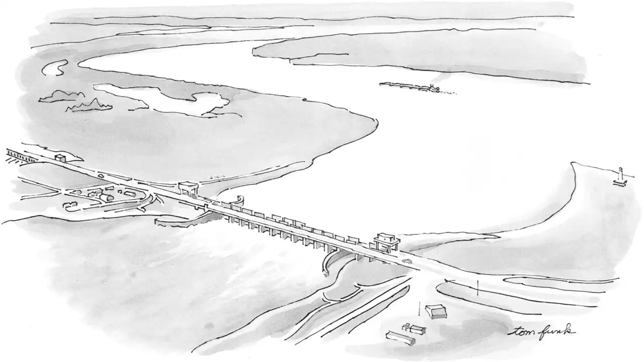
Ten miles upriver from the navigation lock, where the collective sediments were thought to be more firm, they dug into a piece of dry ground and built what appeared for a time to be an incongruous, waterless bridge. Five hundred and sixty-six feet long, it stood parallel to the Mississippi and about a thousand yards back from the water. Between its abutments were ten piers, framing eleven gates that could be lifted or dropped, opened or shut, like windows.
The Corps thought differently, saying, “We can’t let that happen. We are charged by Congress not to let that happen.” Its promotional film referred to Old River Control as “a good soldier.” Old River Control was, moreover, “the keystone of the comprehensive flood-protection project for the lower Mississippi Valley,” and nothing was going to remove the keystone. People arriving at New Orleans District Headquarters, U.S.
There was a high sill next to this one—a separate weir, two-thirds of a mile long and set two feet above the local flood stage, its purpose being to help regulate the flow of extremely high waters. The low sill, as the one we stood on was frequently called, was the prime valve at Old River, and dealt with the water every day. The fate of the project had depended on the low sill, and it was what people meant when, as they often did, they simply said “the structure.
The pilothouse of the Mississippi is a wide handsome room directly above the lounge and similarly fronted with a wall of windows. It has map-and-chart tables, consoles of electronic equipment, redundant radars. The pilots stand front and center, as trim and trig as pilots of the air—John Dugger, from Collierville, Tennessee , and Jorge Cano, a local “contact pilot,” who is here to help the regular pilots sense the shoals of the .
The Army engineers chose half a dozen sites near New Orleans and, setting a pattern, signed up a civilian contractor to build the fortifications. Congress also instructed the Army to survey the Mississippi and its tributaries with an eye to assuring and improving inland navigation. Thus the Corps spread northward from its military fortifications into civil works along the rivers.
In southern Louisiana, the bed of the Mississippi River is so far below sea level that a flow of at least a hundred and twenty thousand cubic feet per second is needed to hold back salt water and keep it below New Orleans, which drinks the river. Along the ragged edges of the Gulf, whole ecosystems depend on the relationship of fresh to salt water, which is in large part controlled by the Corps.
After going on line, in 1963, the control structures at Old River had to wait ten years to prove what they could do. The nineteen-fifties and nineteen-sixties were secure in the Mississippi Valley. In human terms, a generation passed with no disastrous floods. The Mississippi River and Tributaries Project—the Corps’ total repertory of defenses from Cairo, Illinois, southward—seemed to have met its design purpose: to confine and conduct the run of the river, to see it safely into the Gulf.
Kazmann says that the Tennessee River and the Missouri River were “the two main culprits” in the 1973 flood. In one high water and another, the big contributors vary around the watershed. An ultimate deluge might possibly involve them all. After Kazmann went home from Old River that time in 1973, he did his potamology indoors for a while, assembling daily figures. In some of the numbers he felt severe vibrations.
One April evening in 1973—at the height of the flood—a fisherman walked onto the structure. There is, after all, order in the universe, and some things take precedence over impending disasters. On the inflow side, facing the Mississippi, the structure was bracketed by a pair of guide walls that reached out like curving arms to bring in the water. Close by the guide wall at the south end was the swirling eddy, which by now had become a whirlpool. There was other motion as well—or so it seemed.
The water is from the state of New York, the state of Idaho, the province of Alberta, and everywhere below that frame. Far above Old River are places where the floodplain is more than a hundred miles wide. Spaniards in the sixteenth century came upon it at the wrong time, saw an ocean moving south, and may have been discouraged.
The great loop at 31 degrees north happened to he where the Red- conjoined the Mississippi, like a pair of parentheses back to back. Steamboats had had difficulty there in the colliding waters. Shreve’s purpose in cutting off the loop was to give the boats a smoother shorter way to go, and, as an incidental, to speed up the Mississippi, lowering, however slightly, its crests in flood.
The national importance of the commission is perhaps illuminated by the fact that one of its first civilian members was Benjamin Harrison. Another was James B. Eads, probably the most brilliant engineer who has ever addressed his attention to the Mississippi River. As a young man, he had walked around on its bottom under a device of his own invention that he called a submarine. As a naval architect in the Civil War, he had designed the first American ironclads. Later, at St.
For forty-eight years, the Mississippi River Commission and the Corps of Engineers adhered strictly to the “hold by levees” policy—levees, and levees only. It was important that no water be allowed to escape the river, because its full power would be most effective in scouring the bed, deepening the channel, increasing velocity, lowering stages, and preventing destructive floods. This was the hydraulic and hydrological philosophy not only of the U.S.
The levees of the nineteen-twenties were about six times as high as their earliest predecessors, but really no more effective. In a sense, they had been an empirical experiment—in aggregate, fifteen hundred miles of trial and error. They could be—and they would be—raised even higher. But in 1927 the results of the experiment at last came clear. The levees were helping to aggravate the problem they were meant to solve. With walls alone, one could only build an absurdly elevated aqueduct.
The flood-control design of 1928 had left Old River open—the only distributary of the Mississippi to continue in its natural state. The Army was aware of the threat from the . Colonel Charles Potter, president of the Mississippi River Commission, told Congress in 1928 that the Mississippi was “just itching to go that way.” In the new master plan, however, nothing resulted from his testimony.
If the General had known what was below him, he might have sounded retreat. The Old River Control Structure—this two-hundred-thousand-ton keystone of the comprehensive flood-protection project for the lower Mississippi Valley—was teetering on steel pilings above extensive cavities full of water. The gates of the Morganza Floodway, thirty miles downstream, had never been opened. The soybean farmers of Morganza were begging the Corps not to open them now.
The 1973 flood shook the control structure a whole lot more than it shook the confidence of the Corps. When a legislative committee seemed worried, a Corps general reassured them, saying, “The Corps of Engineers can make the Mississippi River go anywhere the Corps directs it to go.” On display in division headquarters in Vicksburg is a large aerial photograph of a school bus moving along a dry road beside a levee while a Galilee on the other side laps at the levee crown.
The Old River Control Auxiliary Structure is a rank of seven towers, each buff with a white crown. They are vertical on the upstream side, and they slope toward the . Therefore, they resemble flying buttresses facing the Mississippi. The towers are separated by six arciform gates, convex to the Mississippi, and hinged in trunnion blocks secured with steel to carom the force of the river into the core of the structure.
I once asked Fred Smith, a geologist who works for the Corps at New Orleans District Headquarters, if he thought Old River Control would eventually be overwhelmed. He said, “Capture doesn’t have to happen at the control structures. It could happen somewhere else. The river is close to it a little to the north. That whole area is suspect. The Mississippi wants to go west. Nineteen-seventy-three was a forty-year flood.
The towboat Mississippi has hit the point of a sandbar. The depth finder shows thirty-eight feet—indicating that there are five fathoms of water between the bottom of the hull and the bed of the river. The depth finder is on the port side of the ship, however, and the sandbar to starboard, only a few feet down. Thus the towboat has come to its convulsive stop, breaking the stride of two major generals and bringing state officials and levee boards out to the rail.
General Sands replies, “I don’t know that I’m personally smart enough to answer that, but I’d say no.” Under nature’s scenario, with many distributaries spreading the floodwaters left and right across the big deltaic plain, visually the whole region would be covered—with fresh sediments as well as water. In an average year, some two hundred million tons of sediment are in transport in the river. This is where the foreland Rockies go, the western Appalachians.
An Alexander Calder might revel in these motions—interdependent, interconnected, related to the flow at Old River. Calder would have understood Old River Control: the place where the work is attached to the ceiling, and below which everything—New Orleans, Morgan City, the river swamp of the —dangles and swings.
Norge Siste Nytt, Norge Overskrifter
Similar News:Du kan også lese nyheter som ligner på denne som vi har samlet inn fra andre nyhetskilder.
 Mayor Garcetti launches River Rangers program to help clean LA River public spacesThe River Rangers program will hire 127 local youth to help service 18 miles of public spaces along the river, including paths, trails and bridges.
Les mer »
 ‘Momentous:' US Advances Largest Dam Demolition in HistoryU.S. regulators approved a plan to demolish four dams on a California river and open up hundreds of miles of salmon habitat that would be the largest dam removal and river restoration project in the world when it goes forward. The Federal Energy Regulatory Commission vote Thursday on the lower Klamath River dams is the last major regulatory hurdle and the biggest milestone for a $500 million demolition proposal championed by Native American tribes and environmentalists for years. The project would return the lower half of California’s second-largest river to a free-flowing state for the first time in more than a century.
Les mer »
 Biden's student loan plan disrupted in federal court, postponing cancellation for Mississippi borrowersA federal appeals court has formally blocked the Biden administration’s student debt cancellation plan, meaning borrowers who expected to see up to $20,000 in loan cancellation this fall must now wait indefinitely for a resolution in the lawsuit.
Les mer »
 Mississippi Today hosts acclaimed media critic Margaret Sullivan in JacksonAcclaimed media critic Margaret Sullivan shared her advice for rebuilding public trust in the media at the Old Capitol Museum Thursday evening, in conversation with Mississippi Today.
Les mer »
 Environmental groups sue DOT over Mississippi road projectA group of environmental and racial justice organizations filed a federal lawsuit on Thursday against the U.S. Department of Transportation and its secretary, Pete Buttigieg, seeking to halt a Gulf Coast road project that the group says will harm the environment near historic Black neighborhoods in north Gulfport.
Les mer »
 Mike Leach will talk officials if you send him $30,000: ‘I’ll give you one heck of an answer’'You go ahead and mail me a check,' Mississippi State Coach Mike Leach said, when asked about officiating. ' I think $30,000 will cover it although ... You go ahead and mail me the check, and I’ll give you one heck of an answer.”
Les mer »